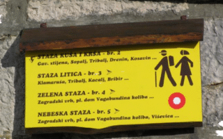
Zelena staza
The trail starts in Luka Krmpotska, near the hunters’ lodge at an elevation of 750 meters, and ends at the summit of Medviđak, at 1,027 meters. The trail is 45 km long and covers the mountain meadows of the southern slopes of Ričičko bilo, Rujnik, and Sitovnik, as well as the peaks of Rujnik (1,042 m), Sitovnik (1,048 m), Zagradski vrh (1,187 m), Kančulova glava (1,120 m), and Medviđak (1,027 m).
These mountain peaks form the first mountain ridge rising above the flat plains of the Vinodol Valley, Pleteno, and Crno. The trail initially leads through beautiful mountain meadows filled with wildflowers, offering stunning views – on one side towards the sea, the Kvarner islands, and Velebit, and on the other side towards the highest peaks of the region, such as Ričičko bilo, Strilež, and Viševica.
After the summit of Sitovnik, the trail enters forest areas. This section features dense fir and beech forests on rugged terrain, alternating with peaceful meadows such as Okruglo, Ravno, Laza, and Suha. Don’t miss visiting Zagradski vrh, named after the traditional stone fences of the Vinodol shepherds, offering exceptional views of Kvarner, Velebit, and even the Alps and Dolomites.
Also, be sure to visit the 'Glass Chapel' near the hunters’ lodge in Luka Krmpotska.